Trail Walking La Grave - vallons de la Meije : lac Puy Vachère - Photo

vallons de la Meije : lac Puy Vachère

 nadinebondoux
nadinebondoux

User GUIDE

© OpenStreetMap contributors
Length
Length
12.7 km
Max alt
Max alt
2406 m
Uphill gradient
Uphill gradient
1040 m
Km-Effort
Km-Effort  
27 km
Min alt
Min alt
1443 m
Downhill gradient
Downhill gradient
1039 m
Boucle
Boucle
Yes
Creation date :
2023-07-20 07:19:42.82
Updated on :
2023-07-21 14:37:02.424

(0 Reviews)

Walking
Walking
5h44
Difficulty : Very difficult

Scan this QR Code to open this trail in the SityTrail application

FREE GPS app for hiking

Logo SityTrail SityTrail

IGN / Geographical institutes

Download SityTrail from the App Store Download SityTrail from Google Play

Logo SityTrail SityTrail World

The world is yours!

Download SityTrail from the App Store Download SityTrail from Google Play Download SityTrail on Huawei AppGallery

About

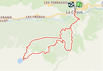
Trail Walking of 12.7 km to be discovered at Provence-Alpes-Côte d'Azur, Hautes-Alpes, La Grave. This trail is proposed by nadinebondoux.

Description

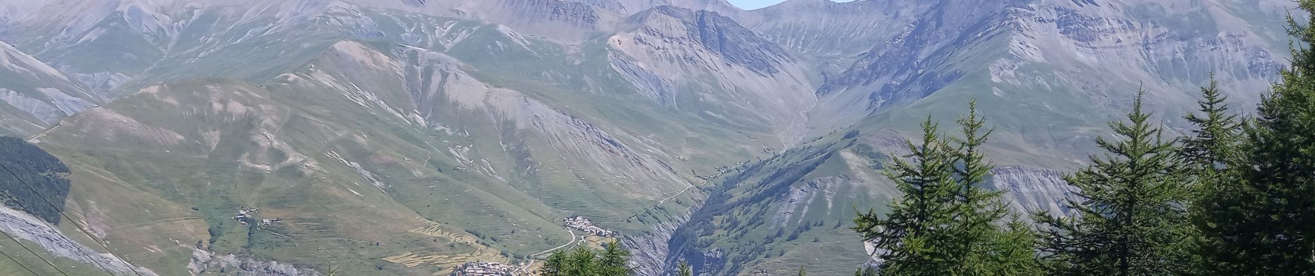
Sentiers de terre ombragés pour une bonne partie  mais très raides

Elevation profile

Photos

Positioning

Country:
France
Region :
Provence-Alpes-Côte d'Azur
Department/Province :
Hautes-Alpes
Municipality :
La Grave
Location:
Unknown
Start:(UTM)
287946 ; 4991576 (32T) N.

Trails nearby

Trail Walking La Grave - L'aiguille du Goléon - Photo
Walking
tracegps

Walking

Very difficult
(1)
La Grave, Provence-Alpes-Côte d'Azur, Hautes-Alpes, France
9.1 km | 25 km-effort
5h 0min
No
Trail Walking Villar-d'Arêne - Lac d'Arsine  - Photo
Walking
GUIDE
nadinebondoux

Walking

Difficult
Villar-d'Arêne, Provence-Alpes-Côte d'Azur, Hautes-Alpes, France
17.2 km | 28 km-effort
5h 37min
Yes
Trail Walking Villar-d'Arêne - SityTrail - Lac du pontet et l'Aiguillon - Photo
Walking

Walking

Medium
(1)
Villar-d'Arêne, Provence-Alpes-Côte d'Azur, Hautes-Alpes, France
5.2 km | 8.6 km-effort
1h 56min
Yes
Trail Walking La Grave - 2020-09-03 Marche Tour de la Grave au plateau d'Emparis par le Pic du Mas de la Grave (3 jours) - Photo
Walking
GUIDE
holtzv

Walking

Medium
La Grave, Provence-Alpes-Côte d'Azur, Hautes-Alpes, France
51 km | 88 km-effort
17h 56min
No
Trail Walking La Grave - 2020-09-03 Marche La Grave au Refuge du Pic du Mas de la Grave - Photo
Walking
GUIDE
holtzv

Walking

Very easy
La Grave, Provence-Alpes-Côte d'Azur, Hautes-Alpes, France
12.2 km | 23 km-effort
4h 58min
No
Trail Walking La Grave - 2020-09-06 Marche La Grave Gare de Peyrou d'Amont au Col des Ruillans - Photo
Walking
GUIDE
holtzv

Walking

Medium
La Grave, Provence-Alpes-Côte d'Azur, Hautes-Alpes, France
6.2 km | 15.7 km-effort
3h 30min
No
Trail Walking La Grave - 2020-09-04 Marche Pic du Mas de la Grave Refuge du Fay - Photo
Walking
GUIDE
holtzv

Walking

Medium
La Grave, Provence-Alpes-Côte d'Azur, Hautes-Alpes, France
17.4 km | 32 km-effort
6h 54min
No
Trail Walking La Grave - Oisans : AR La grave au col de Ruillans (Glacier de Girose) par col du Lac .crea - Photo
Walking
PatDev

Walking

Difficult
(1)
La Grave, Provence-Alpes-Côte d'Azur, Hautes-Alpes, France
16.6 km | 41 km-effort
3h 32min
Yes
Trail Walking La Grave - dome de la Lauze - Photo
Walking
GUIDE
amiral13

Walking

Easy
La Grave, Provence-Alpes-Côte d'Azur, Hautes-Alpes, France
4.8 km | 9.4 km-effort
4h 5min
No


Close
My subscriptions